Written by Brian C. Moon - November 12, 2024
 Geographic Information Systems (GIS) have revolutionized how we collect, analyze, and visualize spatial data. By integrating location-based information with various datasets, GIS provides powerful tools for researchers, students, and faculty across multiple disciplines. Whether mapping disease outbreaks, analyzing environmental changes, or planning urban infrastructure, GIS offers insights critical for informed decision-making. Keep reading below to learn more about GIS, and don’t miss the details of our upcoming GIS Day celebration on Nov. 20th (10am-2pm in Lister Hill Library)—join us to explore innovative GIS applications, connect with enthusiasts, and discover how GIS can enhance your own work.
What is GIS?
 A Geographic Information System (GIS) is a computer-based system that creates, manages, analyzes, and maps all types of data. GIS connects data to a map, integrating location data (where things are) with descriptive information (what things are like there). This integration provides a foundation for mapping and analysis used in science and almost every industry. GIS helps users understand patterns, relationships, and geographic context.
Why Use GIS?
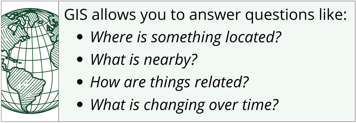
 GIS enables visualization of large and complex datasets, revealing patterns and relationships that might be missed in traditional data analysis. It's not just about making maps; it's about understanding the world in a more dynamic and informed way. By organizing data into discrete layers aligned in geographic space, GIS allows for sophisticated spatial analyses. Visualization is critical for data integrity and understanding.
GIS in Research and Education
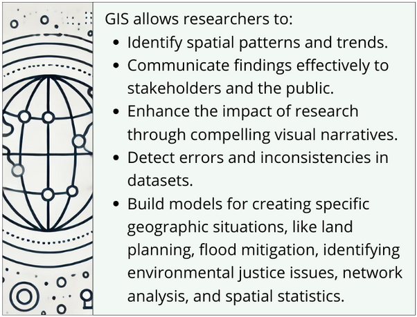
At institutions like the University of Alabama at Birmingham (UAB), GIS plays a pivotal role in advancing research and education. With access to comprehensive GIS tools and resources, researchers and students leverage spatial analysis to address complex challenges in health, environmental science, urban planning, disease surveillance, and more. See below for some examples of how GIS is being used.GIS Resources
The Center for Clinical and Translational Science (CCTS) Partner Network is a collaborative effort that extends resources and expertise across multiple institutions. While this article highlights resources available at UAB, many GIS tools and training opportunities are accessible to all members of the network and beyond. Researchers are encouraged to explore GIS capabilities within their own institutions and through shared resources
For those affiliated with UAB:
- Access to ArcGIS Software: UAB holds an institutional license for Esri's ArcGIS software suite, providing unlimited access for educational and research use. This includes desktop applications like ArcGIS Pro and web-based tools such as ArcGIS Online.
- Geospatial Research and Information Domain (GRID): GRID offers support and resources for incorporating GIS into your work, including training, consultation, and access to datasets. Visit the GRID StoryMap for guidance on getting started.
- UAB Social Determinants of Health Core
- UAB GIS contact: Ariann Nassel, Director of Geospatial Data Visualization
- email: anassel@uab.edu
For those outside UAB:
- Check institutional resources: Verify if your institution has an Esri GIS license. Many universities and organizations have licenses that provide access to GIS software and tools.
- Sign up for a free public account: If institutional resources are not available, you can sign up for a free public account with ArcGIS Online. This account provides access to basic GIS functionalities and is a great starting point. Register at ArcGIS Public Account Sign-Up.
- Explore free training opportunities: Esri offers free online training modules that are accessible to anyone. These courses cover a wide range of topics, from GIS fundamentals to advanced spatial analysis. Browse the catalog at Esri Training Resources.